Nobody Gives a Sh*t About Space: Building an AI Satellite Intelligence Platform
Don't build for the customers willing to tolerate your technology. Build for the millions who can't. We're turning satellite imagery and AI into accessible intelligence for investors and researchers, without expensive contracts, specialist software, or GIS expertise.
We've spent decades launching increasingly sophisticated satellites into orbit.
Today, we can observe almost every corner of the planet, monitor global supply chains, track physical assets, detect environmental changes, and collect extraordinary amounts of information about the world beneath us.
And almost nobody outside governments and enormous corporations actually uses this technology.
Not because the demand isn't there.
Because the experience is @#$%ing absurd.
The satellite industry has spent decades optimising for the people who already understand satellite technology. Governments, intelligence agencies, hedge funds, and massive enterprises with the money, expertise, and patience to navigate extraordinarily complex systems.
Everyone else? Good luck.
When my cofounder Michael, an aerospace engineer and former Royal Navy officer, tried to buy a single archival satellite image as an ordinary customer, it took him nearly a week.
One provider wanted him to fill out a sales form and wait for a business development manager to call. Another accepted his payment but told him the image, captured years earlier, would take 12–48 hours to deliver.
For a picture sitting on a server somewhere.
It's 2026. You can stream a film in 4K from the other side of the planet, but buying an old satellite photograph apparently requires a procurement department and a small act of God.
And that's before you attempt any satellite imagery analysis.
You might need GIS software, specialist training, remote sensing expertise, and an intimate understanding of satellite sensors, spatial resolution, cloud cover, and image processing.
All before you can answer a question that might be as simple as:
"Is that copper mine expanding?"
This was the problem that led us to build Aureum, an AI satellite intelligence platform.
Our thesis was simple.
The world doesn't need another satellite company. It needs a way to actually use the satellites we've already launched.
The Google Maps Moment for Earth Observation
There's a technology that uses satellites and has achieved something remarkable: billions of people use it without ever thinking about space.
GPS.
Think about the absurd engineering involved. Orbital mechanics, atomic clocks, relativistic physics, massive constellations of satellites circling the planet.
And what does the average person see?
A little blue dot on Google Maps.
Nobody opens Google Maps because they're particularly enthusiastic about orbital mechanics.
They open it because they want to know how to get to the pub.
Google Maps didn't make GPS successful by teaching everyone how satellites work. It made GPS successful by making sure nobody needed to know.
That distinction became the foundation of Aureum.
The Earth observation industry has spent decades building better satellites, higher-resolution imagery, increasingly sophisticated sensors, and complicated geospatial intelligence software.
But comparatively little effort has gone into making all of that technology accessible to an ordinary person with an ordinary question.
And therein lies the opportunity.
What if we could give satellite intelligence its Google Maps moment?
What if an individual investor could investigate a mining operation without hiring a geospatial analyst?
What if a journalist could verify physical changes at an industrial site without learning remote sensing?
What if a commodities trader could monitor ports, shipping corridors, and critical mineral supply chains without spending thousands on enterprise-grade alternative data?
What if anybody could simply ask Earth a question and get an answer?
We wrote a fairly provocative argument about this in our manifesto, "Nobody Gives a Sh*t About Space".
And then we decided to put our money where our mouth was.
What We Built: Satellite Intelligence Without the Complexity
We started with one fundamental product decision.
Start with the user's question, not the satellite.
Historically, conducting geospatial intelligence research has meant working backwards through a complicated process:
- Identify the asset or location you're investigating.
- Find a satellite imagery provider covering the area.
- Search an archive for suitable imagery.
- Evaluate dates, resolution, sensors, and cloud cover.
- Acquire and process the relevant data.
- Perform geospatial or satellite image analysis.
- Interpret the results.
- Finally, attempt to answer your original question.
We wanted to collapse that experience into something considerably simpler.
Ask a question. Get an answer.
That became the foundation for two complementary products.
1. Query: AI Satellite Image Analysis in Plain English
**Aureum Query** is our approach to AI-powered satellite imagery analysis.
Instead of asking users to navigate complicated GIS dashboards, satellite data archives, or specialised geospatial intelligence platforms, we let them ask questions in natural language.
Things like:
- Mining intelligence: Is this copper mine expanding its operations?
- Oil and energy: What can satellite observations tell us about activity at this refinery?
- Shipping and logistics: What has changed at this commercial port?
- Infrastructure monitoring: Is construction progressing at this AI data center?
- Geopolitical intelligence: What physical changes can we observe around a strategic chokepoint?
- Open-source intelligence (OSINT): Can satellite evidence help verify a claim about a location?
Behind the scenes, these questions can involve multiple data sources, geospatial reasoning, satellite imagery, and AI analysis.
But the user shouldn't need to care about any of that.
They should care about whether the answer is useful, how current the evidence is, and how confident they should be in the conclusion.
It's important to distinguish between an observation and an inference. Satellite images don't reveal everything. They can be outdated, obscured by clouds, or ambiguous. And a change detected in imagery doesn't necessarily explain why that change occurred.
We're not trying to make satellite intelligence magically infallible.
We're trying to make sophisticated evidence understandable without requiring sophisticated users.
That's the difference between building another GIS tool and building an accessible AI intelligence product.
2. Track: Satellite Monitoring for the Physical Economy
A single answer is valuable.
But the physical world is constantly changing, and for investors, researchers, and commodity traders, understanding those changes over time is often considerably more useful.
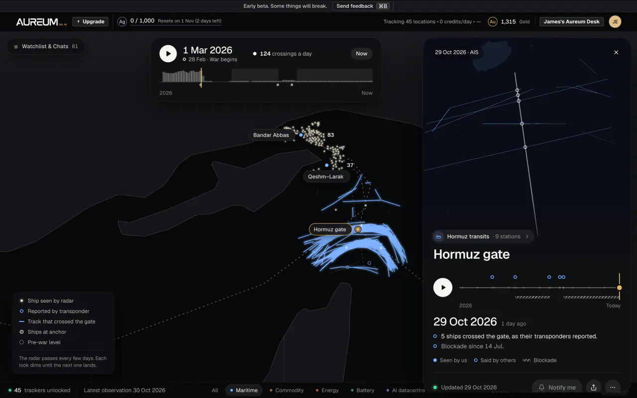
So we built **Aureum Track, our satellite monitoring dashboard**.
Track provides monitoring boards focused on assets and activity that can influence global markets.
Think of it as a window into the physical economy.
Among the areas we're exploring and building around are:
- Oil and gas monitoring: Energy infrastructure, refinery activity, gas flaring, and storage-related signals.
- Mining and critical minerals: Copper mines, lithium extraction, iron ore, bauxite, and mineral processing infrastructure.
- Port congestion and shipping intelligence: Maritime traffic, vessel queues, major ports, and global trade chokepoints.
- Infrastructure and construction monitoring: Industrial facilities, factories, and AI data center development.
- Agricultural commodity intelligence: Export terminals, grain infrastructure, and physical supply-chain activity.
- Geopolitical risk monitoring: Strategic corridors and infrastructure affected by global events.
Our aim is to help individual investors access forms of alternative data for investing that have historically been available primarily to institutional traders and hedge funds.
Not every signal comes from satellite imagery alone. Depending on the tracker, we can combine Earth observation with other relevant sources, including maritime and industry data.
And not every board updates continuously. Satellite coverage varies, so recency and limitations matter.
But the underlying idea is straightforward:
Financial markets run on information. The physical world generates an extraordinary amount of it. Why should access to that information be restricted to the people who can afford Bloomberg-sized budgets?
You can explore the markets and workflows we're building for on our satellite intelligence solutions page.
Our First Wedge: Satellite Data for Individual Investors and Commodity Traders
One of the biggest lessons from building products is that a massive potential market doesn't automatically mean you should try to serve everyone on day one.
Aureum could eventually have applications across journalism, environmental monitoring, insurance, agriculture, supply-chain management, defence, investigative research, and many other industries.
But we needed an initial audience with a specific problem, a strong reason to solve it, and a plausible willingness to pay.
We chose individual investors, especially people researching commodities and the physical economy.
Why?
Because professional investors have understood the value of alternative data for years.
Hedge funds already use satellite imagery, shipping data, industrial activity signals, and other unconventional datasets to inform their research.
But consider the individual investor trying to understand the copper market.
They can read an earnings report. They can follow commodity prices. They can listen to management commentary.
Yet the actual physical assets underpinning those markets — mines, ports, smelters, stockpiles, and processing facilities — are largely invisible to them.
The same problem exists in oil markets, shipping, agriculture, and energy infrastructure.
We're not claiming that satellite observations can perfectly predict commodity prices. They can't.
But they can provide an additional source of evidence that an investor might otherwise never see.
Our bet is that satellite-backed commodity market intelligence shouldn't be a luxury product.
And the opportunity extends far beyond trading.
Once you make something as complex as Earth observation genuinely accessible, users begin discovering applications you never thought to design for.
That, ultimately, is what happened with GPS.
Building With AI: The Interface Is the Innovation
One of the most interesting things about building Aureum in 2026 is how radically AI changes what's possible for a small startup.
A decade ago, creating an accessible satellite intelligence platform might have required a large team of geospatial engineers, remote sensing specialists, machine-learning researchers, and expensive enterprise infrastructure.
Today, AI gives small teams the ability to coordinate remarkably sophisticated technical workflows.
But here's a distinction we've become increasingly convinced matters.
Using AI isn't a product strategy. Solving a problem that AI makes newly solvable is.
Anybody can put a chatbot on top of a dataset.
That's not particularly interesting.
The difficult part is designing a system that connects a user's question to the appropriate evidence, evaluates that evidence, and communicates the result in a way the user can understand.
For Aureum, that means working across several difficult problems:
- Natural language interfaces: Translating everyday questions into meaningful geospatial research tasks.
- Satellite data discovery: Finding relevant observations for the right location and time period.
- AI-powered geospatial analysis: Identifying useful signals from satellite imagery and other physical-world datasets.
- Evidence and uncertainty: Distinguishing what the observations actually show from what the system infers.
- Product simplicity: Turning complex analysis into an experience that doesn't require specialist GIS knowledge.
- Recurring monitoring: Helping users follow important assets rather than manually repeating investigations.
We're building toward an intelligence layer that becomes more useful as we better understand the questions people ask and the evidence required to answer them.
The longer-term opportunity isn't merely to make existing satellite imagery workflows faster.
It's to build a fundamentally different relationship between people and information about the physical world.
What Happened When We Launched
We opened Aureum's public beta at the end of September 2026.
Within our first few weeks, we had attracted thousands of users, and by early November we were approaching 10,000 signups.
For a small startup building what has historically been considered niche enterprise software, that was an encouraging signal.
But we're careful not to confuse signups with product-market fit.
Interest isn't retention.
Curiosity isn't revenue.
And somebody creating an account to investigate an interesting place isn't necessarily somebody who will return every week, let alone pay for the privilege.
That's the challenge we're working through now.
We need to learn which questions create genuine value, which users return, what they want to monitor repeatedly, and which workflows are sufficiently important that people will pay for them.
We're particularly interested in the distinction between a novelty and a habit.
Looking at a satellite image of your childhood home is interesting.
Monitoring the infrastructure behind an investment thesis every week could become indispensable.
Those are very different user behaviours.
And as founders, understanding that difference is far more important than celebrating another thousand signups.
We're also sharing research and practical use cases through Aureum Briefings, where we explore how satellite intelligence can inform commodity research, physical asset monitoring, and investigations into what's happening around the world.
The early traction has strengthened our conviction that the audience for satellite intelligence could be substantially larger than the industry traditionally assumes.
But the real test is still ahead: building something people don't just try, but repeatedly rely on.
What I'd Pass On to Other Builders
There are a few lessons we've taken from building Aureum that apply well beyond the space industry.
1. Your Customers Don't Care How Difficult Your Technology Is
They care whether it solves their problem.
If a user needs to understand your infrastructure before experiencing your product's value, you've probably made your engineering problem their problem.
That's not a feature.
Whether you're building an AI product, developer tool, financial platform, or satellite intelligence service, the principle is the same.
Complexity belongs behind the product, not in front of the customer.
2. Don't Confuse Your Existing Customers With Your Entire Potential Market
The satellite industry has spent decades serving governments and large enterprises.
And understandably so. Those are sophisticated customers with large budgets.
But the industry has often treated the absence of smaller customers as evidence that smaller customers don't need satellite intelligence.
Perhaps.
Or perhaps those customers are absent precisely because nobody has built something accessible enough for them to use.
That's an important distinction.
Sometimes the market doesn't exist because nobody wants the product. Sometimes it doesn't exist because the product is impossible to use.
The second situation is an extraordinary opportunity for a startup.
3. Start With a Narrow Wedge, Even When Your Vision Is Enormous
We're building toward a world where anyone can ask questions about the physical planet.
That's a ridiculously broad ambition.
But our starting point is much narrower: helping individual investors and commodity researchers understand the physical assets and activity behind markets.
The wedge gives us a specific customer, specific workflows, and measurable reasons for people to return.
Without that focus, it's easy to build an impressive demonstration that solves nobody's urgent problem.
A big vision tells you where to go. A narrow wedge tells you what to build on Monday morning.
4. Don't Build a Better Dashboard When You Can Eliminate the Dashboard
The instinct when creating sophisticated technology is to expose more functionality.
More settings. More controls. More charts. More configurable workflows.
And for expert users, sometimes that's genuinely valuable.
But there's another way to approach product development.
What if the user didn't need the dashboard in the first place?
What if they could simply express the outcome they wanted?
This is one of the most important opportunities created by modern AI.
The interface no longer needs to mirror the complexity of the underlying system.
That applies to satellite imagery analysis just as much as it applies to finance, healthcare, legal research, programming, and countless other fields.
5. Make the Underlying Technology Invisible
Nobody uses Google Maps because of the satellites.
Nobody uses a banking app because they love payment infrastructure.
Nobody cares how many databases, APIs, models, or microservices are involved in getting them an answer.
They just want the answer.
We're convinced that some of the most valuable AI products won't be the ones that look the most technologically impressive.
They'll be the ones that make an extraordinarily complicated task feel almost boringly simple.
The Bigger Picture: Making Earth Intelligence Accessible to Everyone
We're still early.
There are substantial technical, commercial, and product challenges ahead. And plenty of ways our assumptions could be wrong.
But our ambition is much bigger than building a nicer satellite imagery platform.
We want to make AI-powered Earth observation and geospatial intelligence accessible to the same kinds of people who today take GPS, search engines, and online maps for granted.
Imagine being able to ask:
- Is this factory actually producing?
- Has this mine expanded?
- What's changing at this oil terminal?
- Are ships accumulating outside this port?
- Is this infrastructure project progressing?
- What's happening to this forest, coastline, or agricultural region?
- What can we independently verify about an event on the other side of the world?
And then getting an answer grounded in observable evidence.
No enterprise sales process.
No specialist GIS software.
No need to know which satellite collected the information.
Just a question and a useful answer.
The next great breakthrough in space might not be a bigger rocket, a better satellite, or a more powerful sensor.
It might simply be making everything we've already launched genuinely useful to everyone down here.
And when that happens, people won't think of it as space technology at all.
They'll just think of it as something they use.
That's the point.
Explore Aureum
We're building an AI satellite intelligence platform for individual investors, with a bigger ambition to make intelligence about the physical world accessible to everyone.
- Aureum Query — Ask questions about real-world assets and locations using AI-powered satellite intelligence.
- Aureum Track — Explore satellite monitoring dashboards for commodities, infrastructure, shipping, and the physical economy.
- Aureum Solutions — Discover use cases across mining, oil and gas, port congestion, critical minerals, supply chains, and investment research.
- Aureum Briefings — Read satellite-backed research and intelligence about global markets and physical-world events.
- **Our Manifesto: Nobody Gives a Sh*t About Space** — The complete argument for why the space industry is broken, and how we intend to help fix it.
Building something similarly ambitious? We'd love to hear what you're working on.
And if you've ever wanted to ask the planet a question, come try Aureum.